West Surrey
This area, comprising the boroughs of Guildford, Surrey Heath, Waverley and Woking, is a dynamic and distinct functional economic area, shaped by its unique geographical, economic and cultural characteristics.
The area is characterised by its innovative and high-growth activities, particularly centred around the University of Surrey and its Research Park in Guildford, which is home to over 200 companies and 4,500 employees. The area contributes significantly to Surrey's GVA, with Guildford alone contributing 12.3% of Surrey’s GVA and 14.5% of jobs.
|
District or Borough |
GVA[1] |
|---|---|
|
Guildford |
£ 6,318 million |
|
Surrey Heath |
£ 3,936 million |
|
Waverley |
£ 3,806 million |
|
Woking |
£ 3,192 million |
|
Total for West Surrey |
£17,252 million |
The area hosts strategic clusters in space tech, environment and sustainability, human and animal health, video games and creative tech, and digital and cyber security. The innovation ecosystem extends via key transport corridors across Surrey, clustering at transport hubs in Guildford and Woking and key institutions, including the University of the Creative Arts in Farnham.
Frimley Health NHS Foundation Trust operates one of its sites at Frimley Park Hospital near Camberley, located in West Surrey. This hospital provides acute services to a population of 400,000 across West Surrey, Berkshire and Hampshire and also hosts the Defence Medical Group South East, providing surgical, medical and care for military personnel. This facility employs over 5,500 staff.
|
District or Borough |
Business births, 2023[2] |
Business deaths, 2023 |
Count of Active Business Enterprises, 2023 |
|---|---|---|---|
|
Guildford |
690 |
605 |
7580 |
|
Surrey Heath |
490 |
470 |
4900 |
|
Waverley |
710 |
700 |
7905 |
|
Woking |
520 |
515 |
5145 |
|
Total for West Surrey |
2410 |
2292 |
25530 |
West Surrey benefits from strong infrastructure offering accessibility, attractive to national and international businesses. Key transport corridors include the A3 Corridor connecting Portsmouth, East Hampshire, West Surrey, and Guildford to London and the M25; the M3 Corridor connecting Southwest Surrey to other parts of the South East; and the South West Main Line connecting areas like Woking and Guildford to London Waterloo. However, the area’s roads are among the most congested in the country, and vital new rail links are needed to Heathrow to improve access to key growth locations, including the University of Surrey.
The A3 Corridor is a major road connecting the London to Portsmouth, passing through key locations such as Kingston upon Thames, Guildford, Haslemere and Petersfield. This corridor is crucial for the strategic road network in Surrey and Hampshire, incorporating large areas of Guildford, Waverley, and Woking, and adjoins Surrey Heath. Major settlements within the corridor include Godalming, Guildford, and Woking. Guildford and Woking are home to global corporations located within existing business/research parks or town centres. The Surrey Research Park is of regional significance with its specialist high-tech and research industries and maintains close links to the University of Surrey. The corridor features major visitor attractions such as RHS Wisley and G-live in Guildford and the New Victoria Theatre in Woking, drawing visitors and increasing the prosperity of the local economy.
|
District or Borough |
Population RQF4 and above[3] |
Earnings by place of residence (gross weekly pay, full time workers) |
Unemployment rate (economically active population aged 16+) |
|---|---|---|---|
|
England |
47.1% |
£732.00 |
3.9% |
|
63.2% |
£843.90 |
2.4% |
|
|
Surrey Heath |
47.7% |
£882.10 |
2.9% |
|
Waverley |
49.2% |
£956.40 |
2.3% |
|
Woking |
58.5% |
£833.20 |
3.4% |
|
District or Borough |
Housing Affordability Ratio[4] |
|---|---|
|
England |
8.32 |
|
Guildford |
11.69 |
|
Surrey Heath |
10.43 |
|
Waverley |
11.89 |
|
Woking |
10.80 |
The West Surrey Strategic Housing Market Assessment (SHMA) 2015 identifies Guildford, Waverley and Woking as being within the same housing market area. This definition reflected evidence of strong migration and commuting links between Guildford, Waverley, Woking and Surrey Heath and similar housing market characteristics. Migration flow analysis based on 2011 Census data found there to be a “complex set of interactions and flows” between authorities in West Surrey and Hampshire.
The strongest relationship was between Waverley and Guildford with a gross migration per head of population of 7.7. Guildford and Woking also had a strong relationship, with a gross migration per head of 5.1. The relationship was strongest between Rushmoor in Hampshire and Surrey Heath, with the next strongest relationship to Woking. The analysis concluded that there are strong migration relationships between Guildford, Waverley and Woking with Guildford being central to these, with strong connections to Surrey Heath.
The SHMA also explored commuting dynamics using 2011 Census data. This analysis noted a particularly strong relationship between Waverley and Guildford and confirmed strong functional interactions between Guildford, Waverley and Woking. Surrey Heath’s relationship was strongest with East Hampshire, followed by Woking. Taking account of the MHCLG’s published criteria that existing district areas should be considered the building blocks for proposals, there is compelling evidence that for the purposes of LGR Surrey Heath should be considered within the same housing market area as Guildford, Waverley and Woking.
|
District or Borough |
Top external commuting destinations outside of London[5] |
||
|---|---|---|---|
|
|
1st |
2nd |
3rd |
|
Guildford |
Waverley |
Woking |
Rushmoor |
|
Surrey Heath |
Rushmoor |
Woking |
Guildford |
|
Waverley |
Guildford |
East Hampshire |
Rushmoor |
|
Woking |
Guildford |
Runnymede |
Elmbridge |
|
District or Borough |
London as a proportion of external commuting[6] |
|---|---|
|
Guildford |
17.3% |
|
Surrey Heath |
16.4% |
|
Waverley |
13.9% |
|
Woking |
20.4% |
|
West Surrey |
17.0% |
The area is one of the least-deprived in the country, although small pockets of notable deprivation exist. House prices are particularly high, creating affordability issues for key workers and resulting in high levels of commuting into the boroughs. The SHMA identifies a significant need for new housing in the area, including a mix of housing types and tenures.
Identifying both Guildford and Woking as Growth Towns, the former Enterprise M3 LEP has pinpointed the A3 corridor as a significant location for future growth and investment. The Growth Towns, which fall within the 100 best performing UK localities, are recognised as crucial to driving economic growth across the South East. Improving connectivity through transport investment schemes within and around the Growth Towns is a key aim of the Strategic Economic Plan.[7] The compact nature of Guildford and Woking mean most in and around them are already easily accessible, but there remain opportunities for promoting greater use of sustainable transport.
The A331/31 and A322 corridors provide strong north-south transport links in the West of Surrey, reflected in the strong bus connections. The efficient local road network enables the high volumes commuting between Guildford, Surrey Heath, Waverley and Woking. By comparison, east to west road connections are far more limited.
Similarly, there are strong cycle paths linkages, such as the Basingstoke Canal route that travels through Guildford, Surrey Heath and Woking
The north of the A3 corridor area benefits from easy access to Heathrow Airport. Gatwick Airport is also located near the three boroughs and the area retains good rail connections to London and the South East generally. However, the A3, which runs through large parts of Guildford, Waverley and Woking, suffers from congestion and rural areas outside the main settlements generally have limited access to public transport, creating a car dependency with associated air quality impacts. Improving rail capacity and securing upgrades to the A3 through Guildford and the A3/M25 Junction 10 at Wisley are crucial to the future growth of the area.
|
District or Borough |
Total rateable properties[8] |
Retail |
Office |
Industry |
Other |
|---|---|---|---|---|---|
|
Guildford |
4480 |
870 (19.4%) |
1310 (29.2%) |
880 (19.6%) |
1410 (31.5%) |
|
Surrey Heath |
2970 |
590 (19.9%) |
780 (26.3%) |
700 (23.6%) |
890 (30.0%) |
|
Waverley |
3980 |
960 (24.1%) |
950 (23.9%) |
890 (22.4%) |
1180 (29.6%) |
|
Woking |
2800 |
740 (26.4%) |
760 (27.1%) |
480 (17.1%) |
820 (29.3%) |
|
West Surrey Total |
14230 |
3160 (22.2%) |
3800 (26.7%) |
2950 (20.7%) |
4300 (30.2%) |
|
District or Borough |
Total non-domestic floorspace[9] (thousands of meters squared) |
Retail floorspace (thousands of meters squared) |
Office floorspace (thousands of meters squared) |
Industry floorspace (thousands of meters squared) |
Other floorspace (thousands of meters squared) |
|---|---|---|---|---|---|
|
Guildford |
1085 |
247 (22.8%) |
265 (24.4%) |
372 (34.3%) |
201 (18.5%) |
|
Surrey Heath |
677 |
136 (20.1%) |
140 (20.7%) |
317 (46.8%) |
84 (12.4%) |
|
Waverley |
641 |
169 (26.4%) |
95 (14.8%) |
252 (39.3%) |
124 (19.3%) |
|
Woking |
768 |
175 (22.8%) |
169 (22.0%) |
350 (45.6%) |
74 (9.6%) |
West Surrey is characterised by areas of countryside, a high proportion of which is Green Belt, interspersed with urban settlements such as Camberley, Guildford, Woking and Farnham. Alongside other ecological and landscape designations, this gives the area distinctive landscape characteristics.
The Thames Basin Heaths Special Protection Area (SPA) and Wealden Heaths SPA are located towards the north and south of the A3 corridor respectively, whilst the Surrey Hills AONB traverses the south of the borough of Guildford and large parts of Waverley. Many visitors are attracted to the area to pursue leisure and recreational activities (such as cycling and walking) within the Surrey Hills, whilst the southern part of Waverley is also commonly regarded as a gateway to the South Downs National Park.
Almost all the areas of the Thames Basin Heaths SPA in Surrey are within West Surrey, a significant proportion of which is within Surrey Heath and north Guildford. This has significant implications for housing development and associated mitigation.
There is a distinctive military history and MOD presence in the West of Surrey, including the Sandhurst Royal Military Academy, Cadet training centre Frimley, Bisley and Ash ranges and Brookwood Cemetery. The importance of these links with the military is significant, with West Surrey hosting training grounds for multiple Aldershot and North Camp barracks, as well as the Solider Academy at ATC Pirbright and Keogh barracks. Additionally, the NRA Olympic base is located here. The MOD is a significant landowner in West Surrey, and a large swathe of the Sandhurst Royal Military Academy site, including its main entrance, falls within the Surrey Heath.
The M3 Corridor, running from Sunbury-on-Thames in Surrey to Eastleigh in Hampshire, is another vital transport link. The motorway serves the densely-populated towns in West Surrey, the north of Hampshire and the south of Berkshire. It also carries traffic heading for busy destinations such as Southampton, Bournemouth, and Poole via the A31, and the southwest via the A303. The M3 connects key locations including Staines, Bracknell, Basingstoke, and Winchester, and is essential for commuting and travel to and from London.
The area is an exceptionally attractive place to live and work, with extensive designated national landscapes, arts and crafts centred on Farnham, which has World Craft Town status, and world-famous heritage.
West Surrey has a population of 470,000, which has grown significantly over the last ten years. Population density is lower than other parts of Surrey, and the median annual pay for those in employment is relatively high.
|
District or Borough |
Current Population[10] |
Population estimates to 2040 assuming 1% growth p.a. |
|---|---|---|
|
Guildford |
149,176 |
173,343 |
|
Surrey Heath |
92,168 |
107,099 |
|
Waverley |
132,146 |
153,554 |
|
Woking |
104,636 |
121,587 |
|
Total for West Surrey |
478,126 |
555,582 |
Despite being an affluent place, West Surrey has pockets of social deprivation, with significant inequalities in healthy life expectancy between wards. Guildford has the largest life expectancy gap, with life expectancy 7.8 years lower for men and 6.9 years lower for women in the most deprived areas compared to the least deprived.
Housing affordability is a critical issue, with the area having some of the most expensive places to live in the country. The average house price is significantly higher than the national average, and the ratio of median house price to median gross annual residence-based earnings is also higher than the average for the south east of England. The area has good superfast broadband coverage at 98%, slightly higher than the English national average, but coverage of 5G is weak, particularly in Waverley.
The 2015 West Surrey Strategic Housing Market Assessment (SHMA) defined a core West Surrey Housing Market Area comprising Waverley, Guildford and Woking, with strong links to Surrey Heath. This reflects evidence of strong migration and commuting links between these areas and similar housing market characteristics. The SHMA also explored commuting dynamics, confirming strong functional interactions between Guildford, Waverley and Woking, with Surrey Heath having strong relationships with Woking.
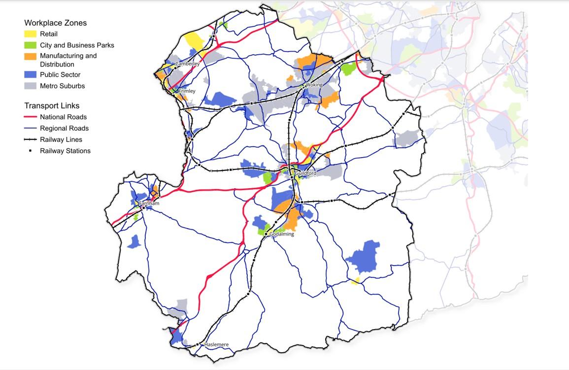
West Surrey map with key towns, workplace zones and transport links
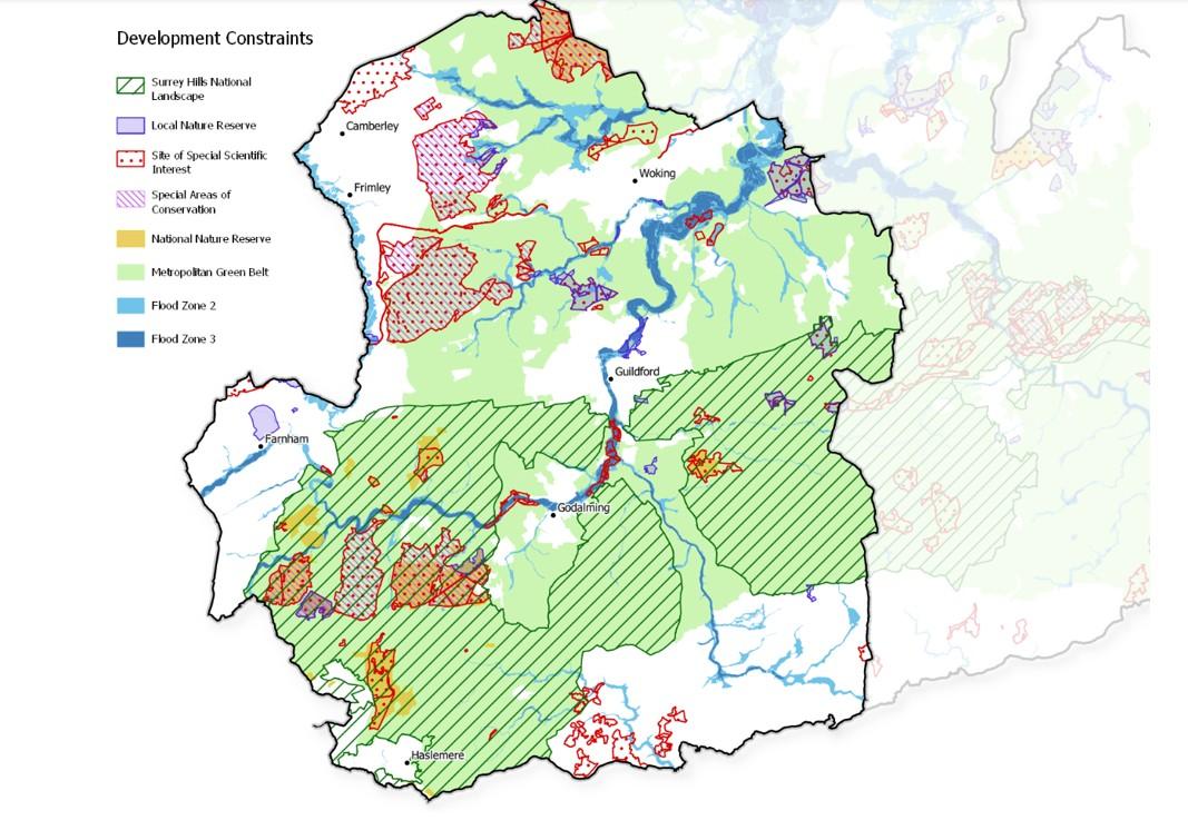
West Surrey map with key development constraints
[1] ‘UK small area gross value added estimates’, ONS, 2024
[2] ‘Business demography, UK: 2023’, ONS, 18 November 2024.
[3] All data from area profiles on 2021 Census and Labour Market Statistics, Nomis.
[4] Ratio of median house price to median gross annual residence-based earnings by local authority district. ‘House price to residence-based earnings ratio’, Office for National Statistics, March 2025.
[5] 2021 Census. There are some limitations on figures due to the influence of the coronavirus pandemic, but figures should nonetheless be indicative of the connections between local areas.
[6] Ibid.
[7] ‘Working for a Smarter Future – the Enterprise M3 Strategic Economic Plan – 2014-2020’, Enterprise M3 LEP, 2014.
[8] ‘Non-domestic rating: stock of properties, 2024’, Valuation Office Agency, 5 February 2025.
Numbers by category are rounded and may therefore not sum exactly to overall total.
[9] ‘Non-domestic rating: stock of properties including business floorspace, 2023’, Valuation Office Agency, 25 May 2023.
Numbers by category are rounded and may therefore not sum exactly to overall total.
[10] ‘2023 mid-year estimates of the population for England and Wales’, ONS, July 2024.
This form helps us improve the content and structure of our webpages only, and we cannot provide a response to any submission below.