North Surrey
This area, comprising the boroughs of Elmbridge, Runnymede and Spelthorne, is characterised by a tightly interconnected network of small towns and villages spread across a relatively compact geography. A significant part of this area is designated Green Belt, which separates the towns and villages and contains the outward sprawl of London. Gaps between settlements are more limited, especially in those areas closer to London. Main settlements include Addlestone, Ashford, Chertsey, Cobham, Egham, Esher, Staines upon Thames, Sunbury, Walton on Thames and Weybridge.
|
District or Borough |
Current Population[1] |
Population estimates to 2040 assuming 1% growth p.a. |
|---|---|---|
|
Elmbridge |
140,500 |
163,261 |
|
Runnymede |
90,442 |
105,094 |
|
Spelthorne |
103,954 |
120,795 |
|
Total for North Surrey |
334,896 |
389,149 |
The River Thames and its tributaries such as the Ash, Bourne, Colne, Mole, and Wey flow through this area and many homes and businesses are at risk from fluvial flooding. There are also a number of major reservoirs, other artificial water bodies and wetland areas as a result of former mineral workings. This is particularly true in Spelthorne where 870 ha of its land area is covered by reservoirs. However, the influence of rivers and ‘blue infrastructure’ in the area contributes strongly to the sense of place, the abundance of recreational opportunities, habitat creation and to the pattern of development. This area is the only part of Surrey containing the River Thames, making it a primary partner in the River Thames flood alleviation scheme.
North Surrey is also home to notable green spaces of heritage, biodiversity and recreational value, such as the Runnymede Meadows (where the Magna Carta was sealed in 1215), Claremont Landscape Garden and Staines Moor, as well as a range of riparian, woodland and heathland habitats.
The area enjoys a coherent confluence of transport networks (M25, M3, Heathrow and with opportunities for transformational radial links with rail opportunities). Further opportunities exist for economic development and housing delivery around enhanced transport hubs and to support new jobs at Heathrow.
North Surrey has strong links to London, with significant commuting patterns to inner London, with all three current boroughs having strong rail ties to Waterloo. Rail access and connectivity between the current borough areas could potentially be strengthened by Heathrow Southern Access railway in the future.
|
District or Borough |
Top external commuting destinations outside of London[2] |
||
|---|---|---|---|
|
|
1st |
2nd |
3rd |
|
Elmbridge |
Runnymede |
Spelthorne |
Woking |
|
Runnymede |
Elmbridge |
Spelthorne |
Woking |
|
Spelthorne |
Runnymede |
Elmbridge |
Slough |
|
District or Borough |
London as a proportion of external commuting[3] |
|---|---|
|
Elmbridge |
59.2% |
|
Runnymede |
30.3% |
|
Spelthorne |
57.8% |
|
North Surrey |
50.6% |
Its accessible location, together with the diverse natural environment and prospering economy, means the area offers a good quality of life. While this has many positive impacts, the desirability of North Surrey as a place to live does mean that affordability pressures in the area are high. Elmbridge is recognised as one of the most expensive places to live nationally, and in all three boroughs, as shown in the table below, house prices are many times higher than median residence-based annual earnings. Unsurprisingly therefore, pockets of deprivation exist across the geography.
|
District or Borough |
Housing Affordability Ratio[4] |
|---|---|
|
England |
8.32 |
|
Elmbridge |
14.34 |
|
Runnymede |
11.24 |
|
Spelthorne |
11.18 |
The area has been considered as a logical grouping in planning terms for many years, with joint working to address strategic issues and priorities. Collaborative efforts in plan making, such as joint methodologies for Green Belt Review and Strategic Land Availability Assessment, further demonstrate an existing strong commitment to planning at a sub-regional level. The three boroughs are on similar timelines for local plan preparation, further cementing strong alignment. Exceptionally, since 2018, the Northern Boroughs have hosted three Nationally Significant Infrastructure Projects (NSIPs) subject to the Planning Act 2008 Development Consent Order (DCO) process:
- Heathrow Airport 3rd Runway Expansion (2018)
- Esso Southampton to London (Heathrow) Pipeline (2024)
- River Thames Scheme (flood alleviation) (2025 - Current)
Further DCOs are expected in the short to medium term, particularly if expansion at Heathrow Airport is agreed. Unification of the North Surrey authorities will build on the established cooperation and integration of strategic planning resources to streamline the DCO delivery process, by providing faster and more cost-effective delivery of current and future NSIPs to accelerate growth.
Economically, North Surrey benefits from its proximity to Heathrow Airport, which influences its high-value business base and attractive residential locations. The area is part of the Heathrow Strategic Planning Group, providing a unified voice in response to Heathrow expansion. Runnymede and Spelthorne share a Strategic Housing Market Assessment and previous work has shown that Elmbridge is also closely aligned with this market area.
North Surrey is also a creative cluster, hosting major film studios like Longcross Netflix and Longcross South Studios in Runnymede and Pinewood (Shepperton Studios) in Spelthorne. Royal Holloway University, renowned for innovation technologies, contributes to the area's creative industries. The area’s economic growth is supported by a strong private sector presence in high value professional services, information and communications, utilities, cyber security, scientific, technical, and wholesale sectors.
The figures below reflect the highly skilled nature of the workforce in North Surrey which attracts higher than average earnings. Across the area as a whole, the unemployment rate is below that recorded for England. Figures are also provided below which show that North Surrey has a healthy overall amount and range of business properties.
|
District or Borough |
Population RQF4 and above[5] |
Earnings by place of residence (gross weekly pay, full time workers) |
Unemployment rate (economically active population aged 16+) |
|---|---|---|---|
|
England |
47.1% |
£732.00 |
3.9% |
|
Elmbridge |
56.3% |
£1010.00 |
3.2% |
|
Runnymede |
45.3% |
£901.50 |
3.1% |
|
Spelthorne |
47.6% |
£778.60 |
4.1% |
|
District or Borough |
Total non-domestic floorspace[6] (thousands of meters squared) |
Retail floorspace (thousands of meters squared) |
Office floorspace (thousands of meters squared) |
Industry floorspace (thousands of meters squared) |
Other floorspace (thousands of meters squared) |
|---|---|---|---|---|---|
|
Elmbridge |
831 |
196 (23.6%) |
205 (24.7%) |
292 (35.1%) |
139 (16.7%) |
|
Runnymede |
686 |
91 (13.3%) |
227 (33.1%) |
208 (30.3%) |
161 (23.5%) |
|
Spelthorne |
770 |
467 (60.6%) |
168 (21.8%) |
309 (40.1%) |
127 (16.5%) |
|
North Surrey Total |
2287 |
754 (33.0%) |
600 (26.2%) |
809 (35.4%) |
427 (18.7%) |
|
District or Borough |
Total rateable properties[7] |
Retail |
Office |
Industry |
Other |
|---|---|---|---|---|---|
|
Elmbridge |
3870 |
1160 (30.0%) |
950 (24.5%) |
640 (16.5%) |
1120 (28.9%) |
|
Runnymede |
2730 |
510 (18.7%) |
700 (25.6%) |
680 (24.9%) |
830 (30.4%) |
|
Spelthorne |
2450 |
790 (32.2%) |
440 (18.0%) |
590 (24.1%) |
630 (25.7%) |
|
North Surrey Total |
9050 |
2460 (27.2%) |
2090 (23.1%) |
1910 (21.1%) |
2580 (28.5%) |
North Surrey has a strong start-up rate with a healthy number of active business enterprises at over 19,000, with business births exceeding business deaths in 2023.
|
District or Borough |
Business births, 2023[8] |
Business deaths, 2023 |
Count of Active Business Enterprises, 2023 |
|---|---|---|---|
|
Elmbridge |
910 |
895 |
9270 |
|
Runnymede |
480 |
420 |
4720 |
|
Spelthorne |
550 |
505 |
5050 |
|
Total for North Surrey |
1940 |
1820 |
19040 |
In wider economic terms, the combined economies of Elmbridge, Runnymede and Spelthorne comprise a significant contribution to the national economy, with a joint GVA of over £18 billion.
|
District or Borough |
GVA[9] |
|---|---|
|
Elmbridge |
£ 6,788 million |
|
Runnymede |
£ 7,231 million |
|
Spelthorne |
£ 4,042 million |
|
Total for North Surrey |
£ 18,061 million |
Combined, these figures reflect the healthy and prosperous nature of the North Surrey economy.
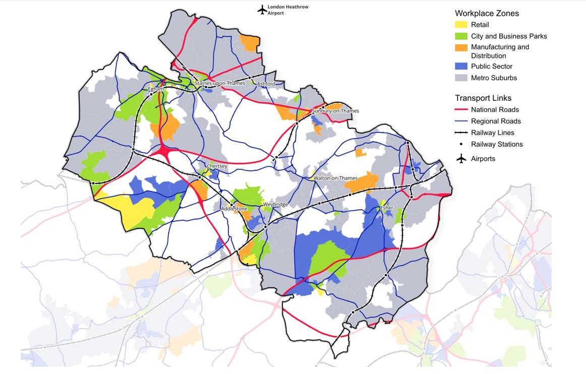
North Surrey map with key towns, workplace zones and transport links
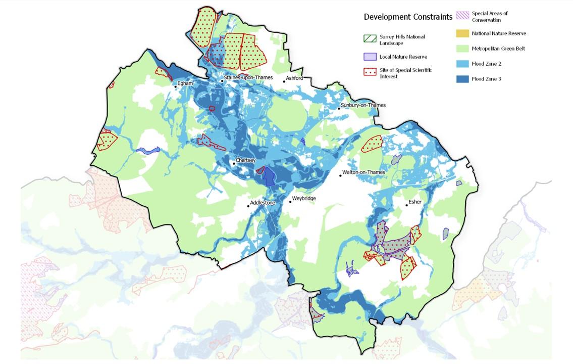
North Surrey map with key development constraints
[1] ‘2023 mid-year estimates of the population for England and Wales’, ONS, July 2024.
[2] 2021 Census. There are some limitations on figures due to the influence of the coronavirus pandemic, but figures should nonetheless be indicative of the connections between local areas.
[3] Ibid.
[4] Ratio of median house price to median gross annual residence-based earnings by local authority district. ‘House price to residence-based earnings ratio’, Office for National Statistics, March 2025.
[5] All data from area profiles on 2021 Census and Labour Market Statistics, Nomis.
[6] ‘Non-domestic rating: stock of properties including business floorspace, 2023’, Valuation Office Agency, 25 May 2023.
Numbers by category are rounded and may therefore not sum exactly to overall total.
[7] ‘Non-domestic rating: stock of properties, 2024’, Valuation Office Agency, 5 February 2025.
Numbers by category are rounded and may therefore not sum exactly to overall total.
[8] ‘Business demography, UK: 2023’, ONS, 18 November 2024.
[9] ‘UK small area gross value added estimates’, ONS, 2024
This form helps us improve the content and structure of our webpages only, and we cannot provide a response to any submission below.